It was very hot in the seattle area - in the 90s - and when it's this hot, it's nice to get out of town. Andrea and I took a long hike in the alpine lakes wilderness area today.
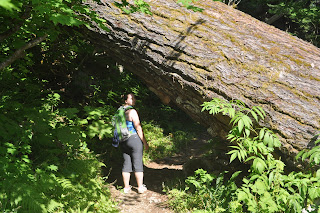
Most of the forests in the lowlands are second or third growth; we look at 50 year old trees as "big", and its nice to be reminded that it wasn't always this way. The tree harvest missed some of the giants, and this hike has thousands of huge trees to show how it used to be. This particular tree is a douglas fir, and is about 180' tall. I'd estimate it at 1200 to 1400 years old. Quietly growing on the side of this mountain for more than a thousand years.
The hike itself is pretty hard; about 2500 vertical feet over 5 miles, but the payoff is pretty spectacular; 7 huge, pristine lakes with crystal-clear water. The water is entirely from snowmelt, and you can see hundreds of feet in it. The logs that fall into the lakes don't rot; you can see layers of them down there, some of them 30' in circumference, like the living trees we passed. They'll still be there hundreds of years from now.
At this point in the year there is still a little bit of snow melting at this altitude; we're at 4500' or so above sea level, and you can see cascade waterfalls off the granite cliffs that surround the lakes.
And there are the giant trees. This one fell across the trail; I don't know what caused it to fall, i couldn't see the top or bottom of the tree from the trail, and in fact, it wasn't clear which direction the top was -- it was so big in diameter that it had no noticeable size difference in the 20' or so visible from that part of the trail. I could probably have climbed, but I was satisfied a casual glance.
In an old growth forest there is a lot more variety in the tree species than in a modern, managed forest. Spruce, hemlock, cedar, alder (some of the biggest alders that I've ever seen are on this hike; I'd estimate 3' DBH - diameter at breast height) and lots of plants that you just dont' see in younger forests. Whole ecosystems that evolve in the thousand years while the tree grows, on the branches of the tree.
How to get there? Take highway 2 towards stevens pass. Turn south (right) on the foss river road - about 15 miles west of the summit. Follow that road about 10 miles, choosing the "west fork of the foss river" when you're given a choice. You'll find yourself at the end of the road, there's a trailhead, bulletin board and permit center. Permits are $5, and cover both day and overnight uses.
Trout lake is an easy 2 mile high up from the trailhead, about 400' vertical gain, and a nice small, clear lake. Call it an hour walk. After trout lake the trail continues 3 miles to the first lakes, Malachite and Copper lakes, with a vertical gain of 1600'. Most of the route is shaded, and there are plenty of views of waterfalls and scenery as you ascend. Once you're up on the main plateau there are a number of very large alpine lakes to choose from; big heart, little heart, etc.
Link with a trip report from someone in 2008, and a map.
4 weeks ago


1 comment:
Wow, I would love to go. We go to the mountains here in GA but it just isn't the same.
Post a Comment